

 |
|---|
 |
 |
 |
 |
 |
 |
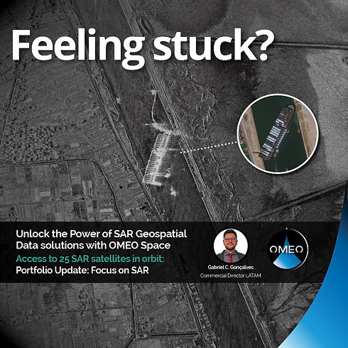
DISCOVER COMPREHENSIVE SOLUTIONS WITH OMEO SATELLITE IMAGERY
Accessing Multiple Earth Observation Satellite Constellations.

MISSION
At OMEO, we're revolutionizing the way the world accesses satellite imagery and geospatial data.
Our team is dedicated to providing advanced satellite imagery solutions that empower businesses and organizations to make informed decisions based on accurate data.
WHY CHOOSE OMEO
Access to powerful satellites with unmatched capabilities.
Earth observation satellites play a crucial role in monitoring our planet. They provide valuable data for climate research, disaster management, and resource monitoring. These satellites capture high-resolution images and collect information on land use, vegetation, and atmospheric conditions. Their insights help scientists and policymakers make informed decisions for a sustainable future.

om30

1 satellite
0.30m PAN
1.2m MS
15cm super resampling
24 km Swath
5 Days Revisit
om3oneo

2 satellites
0.30m PAN
1.2m MS
15 km Swath
5 Days Revisit
Earthscanner
9 satellites
0.50m PAN
2m MS
150 km Swath
2 Days Revisit
dailyvision

54 satellites
0.75m PAN
3m MS
18 km Swath
18x/Day Revisit
nightvision

3 satellites
1.2m
19 km Swath
3 Days Revisit
Video
OUR SOLUTIONS
Unlocking the Power of Earth Observation

SATELLITE IMAGERY ANALYTICS
Gain valuable insights from high-resolution satellite imagery to support various applications such as urban planning, agriculture, environmental monitoring, and more.

GEOSPATIAL INTELLIGENCE
Leverage geospatial intelligence for strategic planning, risk assessment, and resource management through our advanced satellite data processing and analysis.
VALUE ADDED PRODUCTS
We provide a range of value-added products and services, including Digital Surface Models (DSM), Digital Terrain Models (DTM), and OrthoPhotos (DOM). These products are created using fresh stereo satellite imagery and are ideal for terrain, urban environments, and visualization applications.
We offer resolutions of 10m, 5m, 2m, and 1m, with absolute accuracy down to 3m. Additionally, we have world archive coverage available for large-area (country-level) production.

DOWNLOADS
Get access to download datasheets and brochures!


OMEO In Numbers
+130
SATELLITES IN ORBIT
83
VERY HIGH RESOUTION SATELLITES
+100
INTERNATIONAL PARTNER COLLABORATIONS
10
SPEAKING LANGUAGES COVERED WITHIN OUR TEAM


